Atlases Charts and Maps
Showing all 3 resultsSorted by latest
-
Bible Overview Chart
$12.99Add to cartA Comprehensive Graphic Outline in a new PORTABLE MAP STYLE format which allows it
to fit within most Bibles. It outlines the Old and New Testaments of the Bible and is organized chronologically, listing the chapter, book’s author, and significant events. There’s even color coded maps illustrating the location the writings took place making it easier to draw comparisons and analogies between Bible events vs. world events. This chart is a great supplement to any Bible study or can be used as a stand-alone religious timeline. -
Then And Now Bible Maps Insert
$16.99Add to cartRose Bible Map Insert–An ultra-thin Bible atlas that fits in the back of your Bible.
This incredible full color Bible atlas has clear plastic overlays of modern-day cities and countries. Now you can have “Then and Now” Bible maps inside your Bible. Includes 44 pages; 8 plastic overlays; all maps in full color; larger print than other Bible map inserts; every major city in the Bible; a Bible time line; index; separate maps for each of Paul’s Journeys. -
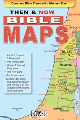
Then And Now Bible Maps Pamphlet
$4.99Where are Bible Lands today? This handy quick reference fold-out shows you! It contains more than a dozen Bible maps that include the modern-day boundaries in red. Fantastic for comparing places in the news with places in the Bible.
Includes the following maps:
*The Middle East during Old Testament Times
*The Assyrian Empire, Babylonian Kingdoms and Persian Empire
*The Holy Land during the time of the Old Testament
*United Kingdom, Divided Kingdom compared with modern-day Israel and surrounding countries
*The Holy Land during the time of JesusAll of Paul’s Journeys (Roman Empire at AD 60)
Fits in the back of most Bibles. Size: 8.5″ x 5.5″ Unfolds 38 inches.
Add to cart3 in stock


